
GeoTomo Products

Seismic Data Processing : Using GeoThrust, you can process 2D and 3D seismic data and produce the final deliverables including RMS velocity model, depth velocity model, prestack-time migration, prestack-depth migration, post-stack migration, and demigration results.

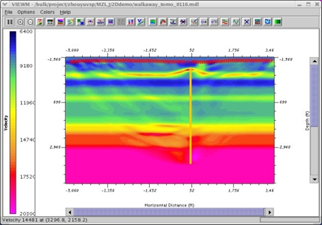
Statics Interpretation : TomoPlus is designed to solve statics problems using tomography approach in both 2D and 3D. It includes a Time Picker as well. The input data is the first-arrival time picks. Tomography produces a near-surface depth velocity model from inverting the first arrivals. And then you can calculate statics from there.

3D VSP Solutions : GeoTomo offers three software packages for VSP solutions. VECON is a 2D/3D survey design and modeling package. It helps you to build velocity models and model the seismic responses.

Crosshole Seismic Solutions : TOMOXPro is a complete crosshole seismic application package. It includes survey design and modeling, raytracing and tomography, processing and migration.

Microseismic Solution : MiVu™ is a software package designed to perform microseismic processing in real time during the hydraulic fracturing operations, in addition to full data processing and interpretation after the hydraulic fracturing has been completed.
 VSP Data Processing : GeoVS™ is a 2D/3DVSP data processing and imaging software for geometries, first break pickers, velocity models, signal processing, Kirchhoff and wave equation migration, and interferometry.
 TOOLKIT FOR INTEGRATING PETROPHYSICS TO SEISMIC : TIPS™ Toolkit for integrating Petrophysics to Seismic. A modular reservoir modeling solution with well-log editing and modeling, AVO modeling, thin bed modeling, multiple modeling along with frequency extension of signal, and multiple estimation and suppression.
 (AI) – Driven Reservoir Interpretation Services : The SeisneticsTM software application uses a unique approach to facies mapping to enhance petroleum systems knowledge and reservoir definition. Seisnetics brings geological relevance to seismic data and leads to precise well placement in frontier and mature basins. Every seismic waveform is optimized to mine crucial information from your entire 3D volume.